Know your horizon
before they take off
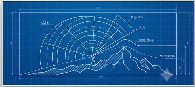
WingIt maps the terrain between your ADS-B antenna and every airport within 150 km — and calculates the minimum altitude a departing aircraft must reach before your receiver sees it.
Optimize placementDrag the pin to test any site. See which airports have clear line of sight vs terrain-blocked.
Predict first acquisitionKnow that CYOW appears at 320 ft AGL and CYUL at 4,800 ft — before the flight starts.
Understand shadowsHills between you and the runway create blind spots. See exactly where and how much mast height fixes them.
How to use
- Enter your address to place the pin
- Drag the pin to your antenna
- Set antenna height (m)
- Tap Find Airports
- Pick an airport from the map or list
- View terrain profile & pickup altitude
Drag pin to antenna location
m AGL